

-
")
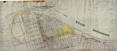
Plat: Part of Memphis (K.C.F.S. & M. Railroad)
Plat titled "Part of Memphis, Tenn.", undated (circa 1891). Shows Memphis, Tennessee, from Union Street in the north to south of the Great Bridge and the route of the Kansas City, Fort Scott and Memphis Railroad through Memphis to Kentucky Avenue. Also shows route of the railroad ferry and the Kansas City, Springfield and Memphis Railroad yard on the Mississippi River further south and other railroad lines.
-
, 1892")
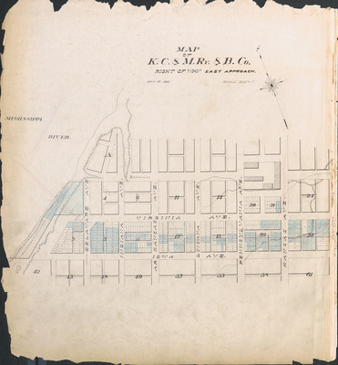
Plat: Right of Way East Approach (K.C.F.S. & M. Railroad), 1892
Plat: Map of Kansas City and Memphis Railway and Bridge Company, "Right of Way. East Approach", 1892. Shows route of Kansas City, Fort Scott and Memphis Railroad line as it enters Memphis, Tennessee, south of Virginia Avenue from Delaware Avenue (Front Street) east to Kentucky Avenue.
-
, 1891")
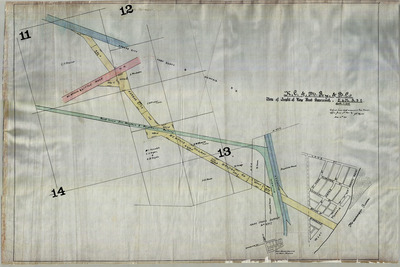
Plat: Right of Way West Approach (K.C.F.S. & M. Railroad), 1891
Plat: Kansas City and Memphis Railway and Bridge Company, "Map of Right of Way West Approach", 1891. Shows route of Kansas City, Fort Scott and Memphis Railroad through West Memphis, Arkansas, to the Mississippi River, including where it crosses other railroads.
-
, 1892")
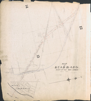
Plat: Right of Way West Approach (K.C.F.S. & M. Railroad), 1892
Plat: Kansas City and Memphis Railway and Bridge Company, "Map of Right of Way West Approach", 1892. Shows route of Kansas City, Fort Scott and Memphis Railroad through West Memphis, Arkansas, to the Mississippi River, including where it crosses other railroads.
Printing is not supported at the primary Gallery Thumbnail page. Please first navigate to a specific Image before printing.