Files
Download
Download Full Text (2.1 MB)
Description
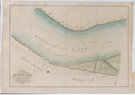
Survey of the harbor of Memphis, Tennessee, by Captain L. Rousseau et al, April 1843. Map shows harbor from above the mouth of the Wolf River to South Memphis and from a block east of Front Street to the Arkansas bank of the Mississippi River. Published by the U.S. Department of the Navy, Washington, D.C.
Identifier
Memp068
Date
1843
Keywords
Memphis (Tenn.)
Recommended Citation
"Map: Memphis, Tennessee, harbor, 1843" (2021). Shelby County, Tennessee. 241.
https://digitalcommons.memphis.edu/speccoll-pub-shelby/241
Rights Statement