

Files
Download
Download Full Text (4.8 MB)
Description
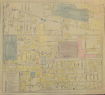
Map of Southeast Memphis, Tennessee, in 1935. The map is centered on the West Tennessee State Teachers College and is bounded by Walnut Grove, Goodlett, Park and Lafayette. The types of land use are color coded.
Identifier
Memp039
Date
1935
Keywords
Memphis (Tenn.)
Recommended Citation
"Map: South East Memphis, Tennessee, 1935" (2021). Shelby County, Tennessee. 245.
https://digitalcommons.memphis.edu/speccoll-pub-shelby/245
Rights Statement