

Publications whose subjects are Memphis and Shelby County, Tennessee.
-

Map: Memphis, Tennessee, 1939
Pocket Map of Memphis, Tennessee, published by the Memphis Chamber of Commerce, 1939.
-

Map: Memphis, Tennessee, 1941
Copy of the New Edition City Map and Guide of Memphis, Tennessee, published by C.A. Davis Printing Co., Memphis, in 1941.
-

Map: Memphis, Tennessee, 1947
Map of Memphis, Tennessee drawn by J. Foster Ashburn and published by First National Bank of Memphis, 1947.
-

Map: Memphis, Tennessee, 1957
Official City Map of Memphis, Tennessee, 1957, published by the Department of Public Works. The map shows the annexations and population changes for the City of Memphis, 1819 to 1957.
-

Map: Memphis, Tennessee, 1959
"Graphic's New Map of Memphis", Tennessee, 1959, published by Graphics Publications, Memphis.
-

Map: Memphis, Tennessee, 1964
Map of Memphis, Tennessee, published on behalf of Union Planters National Bank of Memphis by Graphic Publications, Memphis, in 1964.
-

Map: Memphis, Tennessee, 1965
Map of Memphis, Tennessee, published by Graphic Publications, Memphis, in 1965.
-

Map: Memphis, Tennessee, 1968
Map of Memphis, Tennessee, published on behalf of Philips 66 by H.M. Gousha Company in 1968.
-

Map: Memphis, Tennessee, 1970
Union 76 Memphis, Tennessee, street map from Rand McNally & Co., 1970.
-

Map: Memphis, Tennessee, annexations, 1974
Map published by the Memphis and Shelby County Planning Commission, Memphis, Tennessee, showing the annexations to the city of Memphis from 1819 to 1974.
-

Map: Memphis, Tennessee, annexations, 1975
Map published by the Memphis and Shelby County Planning Commission, Memphis, Tennessee, showing the annexations to the city of Memphis from 1819 to 1975.
-

Map: Memphis, Tennessee, annexations, 1978
Map published by the Memphis and Shelby County Planning Commission, Memphis, Tennessee, showing the annexations to the city of Memphis from 1819 to 1978.
-

Map: Memphis, Tennessee, circa 1921
Map of the City of Memphis, Tennessee, page 202 removed from P.F. Collier & Son's "World Atlas and Gazetteer", circa 1921.
-

Map: Memphis, Tennessee, circa 1927
Ohman’s New Map of City of Memphis and Vicinity published by Theo. W. Ohman Map Company, Memphis, Tennessee, undated (circa 1927).
-

Map: Memphis, Tennessee, District, 1954
District map of Memphis, Tennessee, published by the City Planning Commission in 1954.
-

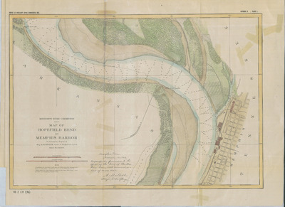
Map: Memphis, Tennessee, harbor, 1843
Survey of the harbor of Memphis, Tennessee, by Captain L. Rousseau et al, April 1843. Map shows harbor from above the mouth of the Wolf River to South Memphis and from a block east of Front Street to the Arkansas bank of the Mississippi River. Published by the U.S. Department of the Navy, Washington, D.C.
-

Map: Memphis, Tennessee, Urban Renewal and Public Housing Projects, 1969
Map of Memphis Housing Authority Urban Renewal and Public Housing Projects, Memphis, Tennessee, 1968.
-

Map: Memphis Transit Authority routes, 1972
Memphis Transit Authority Route Map, Memphis, Tennessee, showing bus routes in July 1972.
-

Map: Plat of Fort Pickering, Tennessee, 1843
Plat of part of the town of Fort Pickering, Tennessee, near Memphis, noting land belonging to John C. McLemore and John Trigg, 1843. Drawn by C. Baumgantner and published by the U.S. Department of the Navy, Washington, D.C.
-

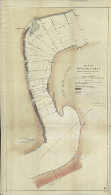
Map: President Island near Memphis, 1862
Plat of President Island near Memphis, Tennessee, January 14, 1862.
-

Map: South East Memphis, Tennessee, 1935
Map of Southeast Memphis, Tennessee, in 1935. The map is centered on the West Tennessee State Teachers College and is bounded by Walnut Grove, Goodlett, Park and Lafayette. The types of land use are color coded.
-

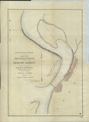
Map: Upper End of Memphis Harbor, 1891
Map of the Upper End of Memphis Harbor, Survey of April 1891. U.S. Army Corps of Engineers map.
-

Memphians in the Limelight, circa 1911
A book of caricatures of leading men in Memphis, including lawyers, businessmen, politicians and officials, produced around 1911 by Roe S. Eastman and E.A. Vaughan and utilizing the talents of cartoonist George W. Curtis. The publisher was Paul & Douglass Company, Memphis. Each cartoon has a brief biography of the subject. This volume has "D. Darnell" embossed on the cover and Douglass Darnell, president of the Memphis Union Stockyards, is included in the book.
